logo
menu
How DIGIPIN Works – Technical Guide to the Indian Digital Addressing System
Want to know how DIGIPIN generates a unique 10-character address from GPS coordinates? This page breaks down the logic, code architecture, and grid-based methodology behind India's smart location coding system. Whether you're a developer, GIS analyst, or just curious — here's everything you need to understand the backbone of DIGIPIN.
Introduction to DIGIPIN
In today’s digital world where GPS, maps, and delivery apps power our daily lives, India’s traditional 6-digit postal PIN code often falls short. Introduced in 1972, the PIN code system was designed to sort mail across broad regions — not to handle today’s need for doorstep accuracy, emergency response, or navigation in remote areas.
But times have changed — and so has the technology.
Enter DIGIPIN — a modern digital addressing system that converts any GPS coordinate in India into a unique, shareable 10-character code. Unlike traditional PIN codes that cover large areas, DIGIPIN gives you a location-specific digital address accurate down to a 4×4 metre square.
What is DIGIPIN?
DIGIPIN is a digital addressing format that encodes any GPS location in India into a precise and compact 10-character code. It divides the entire country into smaller grid zones based on longitude and latitude, helping people, businesses, and systems pinpoint exact locations.
Geographic Location Encoding
The area where DIGIPIN is located is shown. It is not hard to get the latitude and longitude of the address from the DIGIPIN.
India-Specific Design
The Indian environment was taken into account when making DIGIPIN. You can give codes to all of India's spots of interest, including those in the ocean. You can also give each area a unique digital address, even if it is highly crowded.
Intuitive Format
It's easy for people to understand and use the DIGIPIN format. There was an attempt to give DIGIPIN a feeling of direction.
Infrastructure Independence
The land use pattern and the structure developed have nothing to do with DIGIPIN. DIGIPIN is meant to be a permanent digital infrastructure that doesn't alter whether the names of states, cities, or localities change, or when the road network in a region changes.
Future-Proof Design
The DIGIPIN is made to be strong so that it can handle changes and new things that come up in the future. Changes to the name of a road or neighborhood, or the advent of a new building, village, or city in a district, will not modify the underlying DIGIPIN.
Efficient Length
The DIGIPIN's length is meant to be as short as feasible so that it can accurately represent addresses in digital form.
service
My DIGIPIN | Your Location, Digitized — Anytime, Anywhere
Download the DIGIPIN app to generate, share, and manage digital location codes on the go.
Works offline. Fast and accurate. Designed for India.
app-storeplay-store
DIGIPIN Code Structure & Hierarchy
The Detailed structure shows that the DIGIPIN is basically a way to encode the address's latitude and longitude into a string of alphanumeric symbols using these 16 symbols:
2, 3, 4, 5, 6, 7, 8, 9, C, F, J, K, L, M, P, T
Hierarchical Encoding Logic
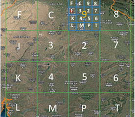
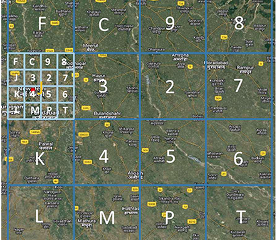
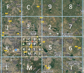
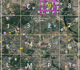
1. A bounding box that covers the whole country is employed.
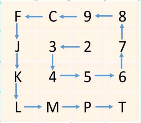
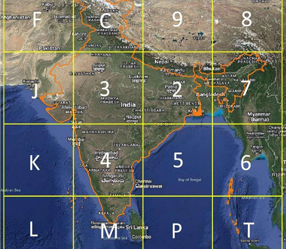
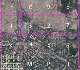
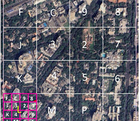
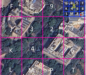
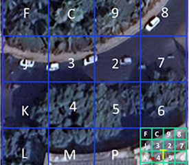
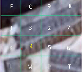
2. Level-1 Partition: The bounding box is divided into 16 areas, each 4x4. One of the 16 symbols marks each area. The first letter in the code tells you which of these areas it is.
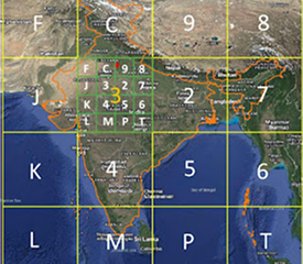
3. Level-2 Partition: Each zone is then split into 16 smaller parts in the same way. The second character tells you what the subregion is, which makes 162 = 256 subregions.
4. Successive Levels: The encoding goes on for 8 more levels in the same way. The 10-symbol code points to one of the 1610 cells in the bounding box.
architecture
Grid labeling pattern showing anticlockwise spiral direction for levels 2-10
Bounding Box Geo-Definitions
  • Longitude: 63.5° – 99.5° East
  • Latitude: 2.5° – 38.5° North
  • Coordinate Reference System (CRS): EPSG:4326 (WGS84)
Bounding Box Design Considerations:
right-1
Includes the entire territory of India.
right-1
Includes the maritime Exclusive Economic Zone (EEZ) - 200 nautical miles from coastline.
right-1
Indian mainland is covered by only 8 regions (digits 2-9 at level-1).
right-1
Level-1 grid lines do not cut through cities with very large population.
right-1
Level-10 cells are approximately 3.8m x 4m at the equator.
Labelling of Regions at Various Levels
Level 1:
right-1
Level-1 labeling uses only digits 2-9 to identify regions on the mainland.
right-1
Codewords beginning with P, W, and X are reserved for future or special uses.
level-1
Level-1 Grid overlay showing regional divisions
architecture
Grid labeling pattern showing anticlockwise spiral direction for levels 2-10
Labelling of Regions at Various Levels
Level 2:
right-1
Each Level-1 region is further divided into 16 Level-2 sub-regions, as illustrated in the figure below. These regions are hierarchically partitioned into sub-regions in an identical manner.
level-1
Level-1 Grid overlay showing regional divisions
right-1
For Levels 2 to 10, the same grid is used for labeling, and the labeling is performed hierarchically.
right-1
Symbols are assigned in an anticlockwise, outward-spiraling fashion. Note that this labeling grid differs from the one used for Level-1. The grid used for Levels 2-10 provides a sense of directionality and adjacency: cells labeled with consecutive symbols (e.g., 6 and 7) are geographical neighbors.
Note: The Level-1 grid, on the other hand, is designed to use numerals 2-9 specifically for mainland India. Furthermore, using two different grids—one for Level-1 and another for Levels 2-9—prevents the inadvertent labeling of locations outside India with the reserved symbols P, W, and X at Level-1.
Code Architecture Illustration: Dak Bhawan Example
The geographical coordinates of Dak Bhawan (28.622788°N, 77.213033°E) demonstrate the selection of DIGIPIN symbols at each level. The DIGIPIN of Dak Bhawan is:
39J-49L-L8T4
LevelSymbolDescription
Level 13Primary region covering North India
Level 29Sub-region within Level 1
Level 3JFurther subdivision
Level 44Continuing hierarchical division
Level 59More precise location
Level 6LNeighborhood level precision
Level 7LBlock level precision
Level 88Building level precision
Level 9TRoom level precision
Level 1044m x 4m grid precision
Level - 1
Level - 1
Levels 2 subdivision
Levels 3 subdivision
Level 4 subdivision
Level 4 subdivision
Level 5 subdivision
Level 5 subdivision
Level - 6 subdivision
Level - 7 subdivision
Level - 8 subdivision
Level - 9 subdivision
Level 10 - Final 4m x 4m precision
Knowledge & Developer Resources
right-2
This documentation was carefully put together using information that is publicly available and information that the Government of India has officially issued on the DIGIPIN program. The Government of India owns the rights to the Images, Documents, and Code. They can only be used for fair and educational purposes.
right-2
The goal is to make it easier to comprehend what DIGIPIN is, why it was created, how it works on a technical and practical level, and how it can affect delivery services, government, and the lives of citizens.
right-2
The technical facts, diagrams, and workflows mentioned in this document all come from official releases or from public presentations, press releases, and pilot project data supplied by universities like India Post and IIT Hyderabad.
right-2
Please use the links below to get more accurate and complete information, or to remain up to date on future developments and official releases.
Available Resources:
Technical Document
Download the complete technical document detailing the code and architecture of DIGIPIN grid
Official Gov Web App
Access the official beta version to capture DIGIPIN values
Programming Code
Download the programming code of the DIGIPIN grid logic
Submit Feedback
Send your comments and suggestions to help improve DIGIPIN
Code Example Breakdown
Your location's DIGIPIN: JTF-7EJ-2J8K
Grid LevelCode SegmentArea Covered
Level 1JTFRegion zone (State/District)
Level 27EJLocal Area or Sector
Level 32J8KMicro block (~4m x 4m)
DIGIPIN is available for all devices
Use our website or mobile app to access location codes anytime. Download now and simplify how you share and manage locations.
app-storeplay-store